|
Open Inventor Release 2023.2.3
|
|

| |
|
Open Inventor Release 2023.2.3
|
|
|
| |
Classes | |
| class | SoExtremaImpositionProcessing |
 SoExtremaImpositionProcessing engine More... SoExtremaImpositionProcessing engine More... | |
| class | SoGrayscaleResconstructionProcessing |
| SoGrayscaleResconstructionProcessing engine More... | |
| class | SoHExtremaProcessing |
| SoHExtremaProcessing engine More... | |
| class | SoReconstructionFromMarkersProcessing |
| SoReconstructionFromMarkersProcessing engine More... | |
| class | SoRegionalExtremaProcessing |
| SoRegionalExtremaProcessing engine More... | |
| class | SoUltimateErosionProcessing |
| SoUltimateErosionProcessing engine More... | |
Geodesy is by definition the science of measuring the shape of the earth. When applied to image processing it is the science of measuring the exact shape of objects included in an image. The geodesic distance is defined as follows:
If two points 


This geodesic distance is actually a distance for any set 
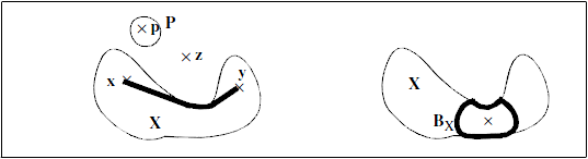
The geodesic notion implies that each particle is fully independent of its neighbours in the image. Moreover, one may introduce the geodesic erosion and dilation. The geodesic dilation is equivalent to a reconstruction in the continuous space. One can show that a discrete geodesic dilation of size 
![\[ t_X(x) = Sup\{d_X(x,y), y \in X\}\]](form_565_dark.png)
It corresponds to the geodesic distance between point