Package com.openinventor.imageviz.engines.mathematicalmorphology.geodesictransformations
Geodesy is by definition the science of measuring the shape of the earth. When applied to image processing it is the science of measuring the exact shape of objects included in an image. The geodesic distance is defined as follows:
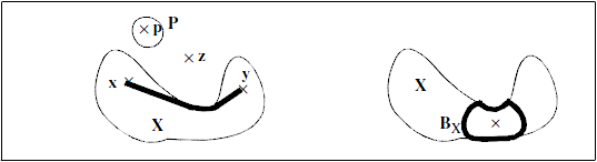
If two points  and
and  belong to
  then
then  is the shortest distance between the two points with the condition that the entire path between the points is included in the particle . If one of the points is outside then
  . If the points belong to 2 disjointed components, then
This geodesic distance is actually a distance for any set without any hole. A geodesic disk,  , is then defined, as shown in figure below.
 The geodesic notion implies that each particle is fully independent of its neighbours in the image. Moreover, one may introduce the geodesic erosion and dilation. The geodesic dilation is equivalent to a reconstruction in the continuous space. One can show that a discrete geodesic dilation of size
  is actually dilations of size 1, each dilation being followed by an intersection with the set . In this case, the underlying discrete distance is defined by the elementary discrete disk (a square or hexagon depending on the grid). The propagation function is then defined as:

It corresponds to the geodesic distance between point and the furthest point of .
-
Class Summary Class Description SoExtremaImpositionProcessing SoExtremaImpositionProcessingengine.SoGrayscaleResconstructionProcessing SoHExtremaProcessing SoHExtremaProcessingengine.SoReconstructionFromMarkersProcessing SoRegionalExtremaProcessing SoRegionalExtremaProcessingengine.SoUltimateErosionProcessing SoUltimateErosionProcessingengine.