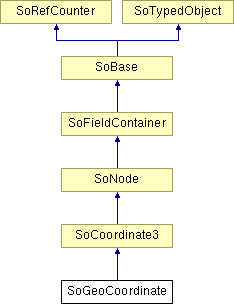
SoGeoCoordinate Class Reference
[Geographic nodes]
 Geographic coordinates node.
More...
#include <Inventor/geo/SoGeoCoordinate.h>

Public Member Functions | |
| virtual SoType | getTypeId () const |
| SoGeoCoordinate () | |
Static Public Member Functions | |
| static SoType | getClassTypeId () |
Public Attributes | |
| SoMFString | geoSystem |
Detailed Description
 Geographic coordinates node.
The SoGeoCoordinate node allows applications to build geometry using geographic coordinates
The SoGeoCoordinate node specifies a list of coordinates in a spatial reference frame. It can be used in place of an SoCoordinate3 node. The geoSystem field is used to define the spatial reference frame and is described in 25.2.3 Specifying a spatial reference frame. The point array is used to contain the actual geospatial coordinates and should be provided in a format consistent with that specified for the particular geoSystem (see above). The geospatial coordinates are transparently transformed into a geocentric, curved-earth representation. For example, this would allow a geographer to create a world where all coordinates are specified in terms of latitude, longitude, and elevation.
FILE FORMAT/DEFAULT
- GeoCoordinate {
| point | [] |
| geoSystem | ["GD","WE"] |
ACTION BEHAVIOR
- SoGLRenderAction, SoGetBoundingBoxAction, SoCallbackAction
- GC: Earth-fixed Geocentric with respect to the WGS84 ellipsoid.
- GD: Geodetic spatial reference frame.
An optional second string may be used to specify the ellipsoid used. If no ellipsoid is specified, then "WE" is assumed (the WGS84 ellipsoid). - UTM: Universal Transverse Mercator
One further required argument must be supplied for UTM in order to specify the zone number (1..60). This is given in the form "Z<n>", where "<n>" is the zone number. An optional argument of "S" may be supplied in order to specify that the coordinates are in the southern hemisphere (otherwise, northern hemisphere will be assumed). - Inventor/geo/SoGeoCoordinate.h
Constructor & Destructor Documentation
| SoGeoCoordinate::SoGeoCoordinate | ( | ) |
Constructor.
Member Function Documentation
| static SoType SoGeoCoordinate::getClassTypeId | ( | ) | [static] |
Returns the type identifier for this class.
Reimplemented from SoCoordinate3.
| virtual SoType SoGeoCoordinate::getTypeId | ( | ) | const [virtual] |
Returns the type identifier for this specific instance.
Reimplemented from SoCoordinate3.
Member Data Documentation
Defines the spatial reference frame.
Valid values are:
The documentation for this class was generated from the following file: