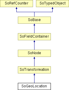
SoGeoLocation Class Reference
[Geographic nodes]
 Used to georeference models.
More...
#include <Inventor/geo/SoGeoLocation.h>

Public Member Functions | |
| virtual SoType | getTypeId () const |
| SoGeoLocation () | |
Static Public Member Functions | |
| static SoType | getClassTypeId () |
Public Attributes | |
| SoSFVec3d | geoCoords |
| SoMFString | geoSystem |
Detailed Description
 Used to georeference models.
The SoGeoLocation allows to place a non-georeferenced model at its correct location in geospatial coordinates.
The SoGeoLocation node provides the ability to geo-reference any models. That is, to take an ordinary model, and to specify its geospatial location. This node is a grouping node that can be thought of as a Transform node. However, the GeoLocation node specifies an absolute location, not a relative one, so content developers should not nest GeoLocation nodes within each other. The geoSystem field is used to define the spatial reference frame and is described in 25.2.3 Specifying a spatial reference frame. The geoCoords field should be provided in the format described in 25.2.3 Specifying a spatial reference frame. The geoCoords field can be used to dynamically update the geospatial location of the model.
FILE FORMAT/DEFAULT
- GeoLocation {
| geoCoords | 0 0 0 |
| geoSystem | ["GD","WE"] |
ACTION BEHAVIOR
- SoGLRenderAction, SoRayPickAction, SoGetBoundingBoxAction, SoCallbackAction, SoGetMatrixAction, SoGetPrimitiveCount
- GC: Earth-fixed Geocentric with respect to the WGS84 ellipsoid.
- GD: Geodetic spatial reference frame.
An optional second string may be used to specify the ellipsoid used. If no ellipsoid is specified, then "WE" is assumed (the WGS84 ellipsoid). - UTM: Universal Transverse Mercator
One further required argument must be supplied for UTM in order to specify the zone number (1..60). This is given in the form "Zn", where n is the zone number. An optional argument of "S" may be supplied in order to specify that the coordinates are in the southern hemisphere (otherwise, northern hemisphere will be assumed). - Inventor/geo/SoGeoLocation.h
Constructor & Destructor Documentation
| SoGeoLocation::SoGeoLocation | ( | ) |
Creates a geoLocation node with default settings.
Member Function Documentation
| static SoType SoGeoLocation::getClassTypeId | ( | ) | [static] |
Returns the type identifier for this class.
Reimplemented from SoTransformation.
| virtual SoType SoGeoLocation::getTypeId | ( | ) | const [virtual] |
Returns the type identifier for this specific instance.
Reimplemented from SoTransformation.
Member Data Documentation
Geospatial coordinate used for translation.
Defines the spatial reference frame.
Valid values are:
The documentation for this class was generated from the following file: