Class SoGeodesicPropagationProcessing2d
- java.lang.Object
-
- com.openinventor.inventor.Inventor
-
- com.openinventor.inventor.misc.SoBase
-
- com.openinventor.inventor.fields.SoFieldContainer
-
- com.openinventor.inventor.engines.SoEngine
-
- com.openinventor.imageviz.engines.SoImageVizEngine
-
- com.openinventor.imageviz.engines.mathematicalmorphology.distancemaps.SoGeodesicPropagationProcessing2d
-
- All Implemented Interfaces:
SafeDisposable
public class SoGeodesicPropagationProcessing2d
extends SoImageVizEngine
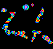
SoGeodesicPropagationProcessing2dengine. For an introduction to geodesy, see section Geodesy Principle.The result of the
SoGeodesicPropagationProcessing2dCommand, applied to a binary image without holes, is a grey level image where each pixel has a grey level value equal to . The following image contains the result of a geodesic propagation on an image to differentiate the various grey level values appearing as stripes or rings. For the largest particle,
  has a minimum of 36 and then values spread until 70 at the extremities. It means that the shortest distance is 36 and the length of the particle can be considered as equal to 70. For particles close to a disk, the geodesic center is located at the center of the particle, and points with the same grey level value are concentric rings.
 The geodesic function has a minimum for each particle which is either a point or a region, named the geodesic center of the particle. The value of this minimum is named the geodesic radius of the particle, as a circle drawn from any of the geodesic center points with such a radius will hit the extremities of the particle.
The maximum is reached at points usually located at the extremities of the particles named geodesic extremities. The value of this maximum is named the geodesic diameter and is seldom equal to 2 times the geodesic radius. In the case of a disk, the center is the geodesic center and the diameter is the geodesic diameter.
File format/default:
GeodesicPropagationProcessing2d {
inBinaryImage NULL
Library references: propagation
-
-
Nested Class Summary
-
Nested classes/interfaces inherited from class com.openinventor.imageviz.engines.SoImageVizEngine
SoImageVizEngine.ComputeModes, SoImageVizEngine.EventArg, SoImageVizEngine.Neighborhood3ds
-
Nested classes/interfaces inherited from class com.openinventor.inventor.Inventor
Inventor.ConstructorCommand
-
-
Field Summary
Fields Modifier and Type Field Description SoSFImageDataAdapterinBinaryImageThe input binary image.SoImageVizEngineOutput<SoSFImageDataAdapter,SoImageDataAdapter>outImageThe output image.-
Fields inherited from class com.openinventor.imageviz.engines.SoImageVizEngine
onBegin, onEnd, onProgress
-
Fields inherited from class com.openinventor.inventor.Inventor
VERBOSE_LEVEL, ZeroHandle
-
-
Constructor Summary
Constructors Constructor Description SoGeodesicPropagationProcessing2d()Constructor.
-
Method Summary
-
Methods inherited from class com.openinventor.imageviz.engines.SoImageVizEngine
abortEvaluate, isEvaluating, startEvaluate, waitEvaluate
-
Methods inherited from class com.openinventor.inventor.engines.SoEngine
copy, getByName, getOutput, getOutputName
-
Methods inherited from class com.openinventor.inventor.fields.SoFieldContainer
copyFieldValues, copyFieldValues, enableNotify, fieldsAreEqual, get, getAllFields, getEventIn, getEventOut, getField, getFieldName, hasDefaultValues, isNotifyEnabled, set, setToDefaults
-
Methods inherited from class com.openinventor.inventor.misc.SoBase
dispose, getName, isDisposable, isSynchronizable, setName, setSynchronizable, touch
-
Methods inherited from class com.openinventor.inventor.Inventor
getNativeResourceHandle
-
-
-
-
Field Detail
-
inBinaryImage
public final SoSFImageDataAdapter inBinaryImage
The input binary image. Default value is NULL. Supported types include: binary color image.
-
outImage
public final SoImageVizEngineOutput<SoSFImageDataAdapter,SoImageDataAdapter> outImage
The output image. Default value is NULL. Supported types include: grayscale binary label color image.
-
-